Water
Given that we detected a positive association between agriculture and the prevalence of Schistosoma infections that seems to be mediated by aquatic vegetation (i.e., Ceratophyllum demersum), we predicted that, by removing vegetation from water access points, we could disrupt this relationship (see Disease tab for disease results) and increase open water access (Fig. 1).
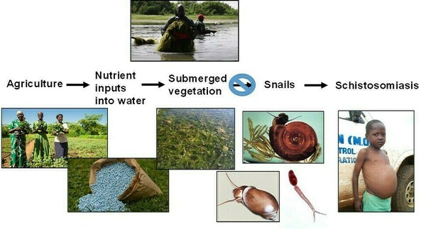 Fig. 1. Hypothesis that removing aquatic vegetation should reduce human schistosomiasis by reducing habitat for snails, the intermediate host for the pathogen.
To test this hypothesis, we implemented a three-year cluster randomized controlled trial in 16 communities (i.e., clusters) in Senegal, quantifying effort to remove vegetation and abundance of snails, aquatic vegetation, open water, and Schistosoma infections in >1,400 schoolchildren before and after vegetation removal in half of the communities. The more of this invasive vegetation we removed, the greater the area of open water access available to community members. Additionally, we detected no long-term effects of removing the overgrowth of C. demersum on water chemistry, quality, or non-target species (Rohr et al. 2023). We expect that the limited scale of invasive vegetation removal – only at water access points – may obviate any ecosystem effects. Additionally, before the Diama Dam was constructed in St. Louis, Senegal, there was less agriculture, less vegetation, and lower schistosomiasis prevalence (Fig. 2, from Rohr et al. 2023). So, removing this invasive vegetation is likely shifting these systems toward an earlier, pre-disturbance state.
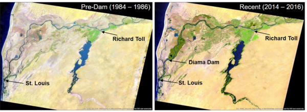 Fig. 2. Google Earth Engine images of the St. Louis/Richard Toll region of Senegal before (1984-1986) and after (2014-2016) the opening of the Diama Dam on August 12, 1986, which was constructed to reduce saltwater intrusion and facilitate irrigation of the region. Note the profound increase in the amount of greenery in the landscape after the opening of the Dam. Image attribution: Esri, HERE, DeLorme, MapmyIndia, © OpenStreetMap contributors, and the GIS user community.
For more information, see Rohr et al. 2023.